Archive for the ‘Exercise’ Category:

First GPS Run

January 28th, 2008

Today I finally got to use my new gps watch (give it up for no rain). Check out my run from 116 San Jose (home) to Mt. Davidson and back (or all my runs online). Chart details is especially cool – When you click on it, opens a chart with elevation, pace, and heart rate info. Mt. Davidson is the tallest natural point in SF at 925 feet. GPS elevation is close, but the elevation gain on the summary data seems way off.

GPS Watch

January 22nd, 2008

Today I got a new toy!!!! A brand new GPS-enabled heart-rate-monitor super watch, the Garmin Forerunner 305. It’s the ideal gadget for serious runners and triathletes. Not that I’m a serious runner, but I do love to geek out. The GPS is pretty robust, allowing the device to record your route as you run (GPS accuracy within 10 meters, typical). The heart rate monitor keeps track of your pulse (of course), so you can see how hard you’re working. And its got all sorts of timers and alerts and other stuff.

The main reason I got it is because I *do* run and wanted to track my routes. After some looking, I was sold by this one picture – it shows a map of SF with the route highlighted, and some stats on the left. Exactly what I was looking for. Thanks for the pic, Bijan Sabet.


Thanksgiving

November 23rd, 2007

Yesterday was the big day. For me, this year’s thanksgiving was especially big, for several reasons. First, i ran my first real race – a half marathon. Second, I got to enjoy the big meal with my family on Tybee Island, a mini-vacation for the 10 of us. And third, after thinking about it, I have much to give thanks for.

First lemme tell you about the half marathon. It was the Atlanta Track Club’s Half Maration, starting at 7am on Thanksgiving day (route). I had to get up at 5:15am for that – that’s 2:15am California time – so thats like crazy early for my body. But i did it, and my younger sister Leslie and her husband were there with me. Luckily it wasn’t too cold, but it did rain on us, which sucked. I ended up doing quite well, beating my secret goal of doing it under 2 hours – 1:56 to be exact. Hurray. After the race they gave you a medal, powerade, water, bananas, snickers protein bars, among other things. But the best part is that you burn tons of calories .. so later that day i was super hungry and got to eat enormous amounts of turkey and sides – guilt-free.

After the race in Atlanta we drove 4-5 hours down to Tybee Island, which is near Savannah on the coast of Georgia. My sister Lara and her family sold their house in Ohio this summer and moved down here for a year. Just because they want to. My kind of family. The house is gorgeous – 3 bedroom with a deck (and hot tub) with a gorgeous view of the coastal marsh and setting sun. We had alot of traditional items for us Norwoods – Turkey, dressing, stuffing, cranberries, Ham, corn, mac’n’cheese, broccoli cheese casserole, sweet potatoes, rolls, and mixed vegies. Mmmmmmmm….

Most importantly, I give thanks. I am so thankful to have such a good, solid, family. We don’t always get along, but for the most part we are very compatible, and I really enjoy spending time with them. I also have to give thanks for my friends, which are just as important to me as my family. These are the people with whom i spend most of my time – i have fun with them, i learn from them, and i get help from them when needed. I also give thanks for my life so far – the opportunities I’ve had with education, jobs, traveling, and the ability to choose where i live and how i can spend my time. For that i must give thanks to being an American. I truly feel blessed. Amen.

Hike to Mt. Carmel

November 16th, 2007

I love Mountains. Wednesday I drove 3 hours south from SF to Mt. Carmel, one of my favorite day hikes from the Bay area (gotta love unemployment). The hike was about 10 miles roundtrip, starting from Bottcher’s Gap up to the peak of Mt. Carmel. From the 4417 foot peak of Mt. Carmel you get a beautiful 360 view, including the ocean to the west, Carmel, Monterey and Santa Cruz to the north, and the mountains east and south. Specifically, I love looking east and south at the huge mountains of the Ventana Wilderness – some peaks are over a mile high (and right next to the ocean). Along the hike you get diverse views and varying vegetation. Some parts are hot/desert/shrubs, other sections had lush vegetation along the creeks, and there was also some parts that felt like east coast – big oak trees with Fall leaves on the ground. Beautiful. Only thing that sucked was lots of gnats in the beginning – but its nothing if you come from the east coast like me. I still recommend it to anybody in decent shape – took me 3 hours to hike up, 1.5 to go down, with 45min break up top.

Next i want to do a weekend trip to Sykes Hot Springs (thanks Mark Verber), (nytimes). Hopefully in December.

RUN

November 12th, 2007

(Updated list of runs below)

I’ve always craved exercise regularly, whether its been mountain biking, backpacking, or dancing all night. But these days i want easy, cheap, regular exercise that doesn’t take too much time – and running fits the bill perfectly. I find myself doing things “runners” do, like checking out running websites, looking for interesting runs around SF, looking for “good” running shoes, and .. yes .. running races. Thanksgiving day, I’m running the 4th largest Half Marathon in the United States in Atlanta with my sister. Hurray.

I’m actually surprised that i’m able to run these days without the knee problems i used to have. I attribute that to my more disciplined approach of exercising more regularly and ALWAYS stretching after I run – i never stretch before. I also have coffee in the morning, then run before lunch while i’m still got that delishous caffeine in my system. I’m surprised by how much energy i have to run – an hour is over and i’m not even tired. I usually just run for 30-60 mins around the mission, castro, and noe valley, but heres a few of my longer runs:

2008 UPDATE – find my runs on motionbased, super easy with new GPS watch.

Sun, 12/2/07, I ran a DSE 4 mile run along Embarcadero in 30 mins exactly (7.5 min/mile).

Thur, 11/22/07, I ran a Half-marathon in Atlanta (13.1 miles) in 1:55 (115 mins, 8.1 min/mile).

Tues, 11/6/07, I ran from 116 to Ocean and back (11 miles) in about 110 mins (8.2 min/mile).

Tues, 10/24/07, I ran from 116 to Heron’s Head Park and back (7.3 miles – extra mile in park) in about 70 mins.

Also, check out the SF bike map – it shows how steep streets are – good for runners and bikes.

Lamayuru to Padum

July 28th, 2007

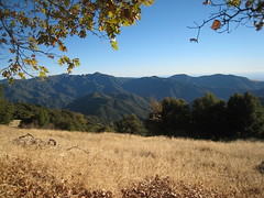
Updated 7/2008 with my pics. orig pic

Between Sengi La and Margun La

I already mentioned getting my trek on in India – well, I survived the 10 days. But my laptop didn’t, and my iPod ran away. More importantly, I saw amazing mountain peaks and valleys, powerful rivers, crystal clear streams, horses, sheep, yaks, and donkeys, locals, other trekkers, villages and gompas (monastaries). But mostly i stared at rocks at my feet as i hiked 4 to 8 hours a day for 10 days. The exercise, fresh air, and beautiful scenery made this one of my favorite parts of my Round the world trip.

Unloading at Lamayuru - Day 1

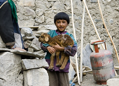
I hiked with 7 others – 4 others who payed, and 3 who got paid. The 4 other trekkers were all from Switzerland – 2 Swiss German, Amir and Patrick, and two Swiss French, Sam and Jo (the only girl). They met each other on the bus to Leh and organized this trip. I just happen to find a sign that said they were looking for more peeps and joined just 2 days before we left. The 3 who got paid were 2 guides and a ponyman. The ponyman is a local dude who carries the stuff – ours had 2 horses and 4 ponies. His english was practically non-existant, but his spirit was great. The 2 guides, Rigzen and Thinles, were from Leh and were quite entertaining. Rigzen was the main guide, young and smart, a bit more reserved than Thinles, and hiked with us every day. Thinles (pronounced tin-less) was his friend and assistant, mostly hiking with the ponyman. Both could speak Ladakhi (local language), Hindi (india national language) and English. Thinles’s english was barely passable, but always entertaining. “Today is much problem, you know?” or just “today is .. you know, by god”. At night they cooked us amazing dishes like .. rice, soup, and vegies (‘amazing’ said in my sarcastic voice). Actually, except for the lack of protein, food was OK – just kinda boring and flavorless. But when you hike and burn so much calories, food cannot taste bad, and i was always thankful to have plenty to eat for dinner.

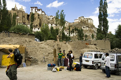
The route was from Lamayuru to Padum – from north to south, starting in Ladakh region and ending in Zanskar. It is commonly called the Zanskar trek, although there are other routes going thru Zanskar. Total distance was 136km (85 miles), with much elevation gain and loss – 8 passes total. It takes 5 to 10 days (well, locals do it in 5, most tourists do it in 8-10). We technically hiked it in 9 days, since the first day was a wash waiting for the ponyman to show up. Stupid late ponyman. We left Leh on July 4 and arrived in Padum on July 13. The route we took is the same as the one discussed in the previously mentioned book, “Trekking in Ladakh“, pages 197, 269-245. I got most of details from there. I even plotted the places we stayed on google earth. View my hike on google maps. (not as cool as this guy’s google earth video from nepal).

Baby Sheep and Wanla Child

I chose this route cuz it was supposed to be more challenging – a bit longer than most, with alot more elevation gain and loss. Over half the people who come to region do the markha valley, a 5-8 day trek right by Leh. I had the time so i wanted to do something a bit longer and more remote. There are only a handful of options, and this one was sold to me as having more dramatic moutains, amazing river valleys, ancient gompas, and varied geological terrain. I found it to be true, for the most part. The beginning and end were less physically demanding than the middle days. After a blister popped and got infected on the 8th day, i was glad to only have to limp 4 hours a day instead of 8. And yes, it really sux to have an infected toe while traveling.

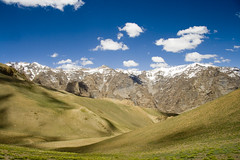
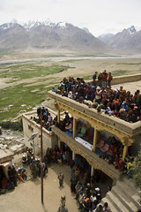
One thing that surprised me was how brown the mountains were. Hardly any dirt, just rocks – various rock colors – purple, red, yellow, aqua/green, white, black, etc, but mostly brown. I was also surprised to find so many “tea houses” along the trail. A tea house is often a tiny stone house where people stop to have … tea. (never would have guessed, that, would ya?) mostly chai, a tea with milk, sugar, and a few spices. In fact, every night except once we had a tea house. They also had ramen noodles, potato chips, and a few other snacks. A few times they even had beer – a delishous treat after a long day’s hike, even when it was warm. Other interesting things included waking up next to donkeys, horses, yaks, and goats, and seeing a local festival in Karsha on the last day. That was quite cool – hundreds of people came dressed in their best, very colorful, regional clothing to the biggest Gompa in Zanskar.

Chad Rides The Donkey

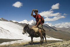
The worst time on the trek was on the fifth day – the day it snowed. It was the only time in my 6 months where i was seriously asking myself, “what the hell am i doing here?”. It started with an overcast morning, warm as always, but with chance of rain i put on my “waterproof” pants and packed a jacket. As we head out, light rain started, and within a couple hours, as we were close to going over Sengi La (the highest pass on the trek, around 5,000 meters, 16,400 ft) the rain had turned to snow. At this point i my legs were soaked (don’t buy “waterproof” pants in India) as was the rest of my body. But my blood was pumping and I did not feel too cold. The snow got worse, and everybody ducked into a tea house just north of the pass. Weather was too bad to cross the pass, the locals said, so we had to wait for our ponyman to show up with the stuff so we could setup camp. We were there for about 3-4 hours, and i was uncontrollably shivering the whole time – except for a short period where an extra stove was placed near us to warm us up. That was heaven. Besides the 6 of us, there was a team from poland, about 14 peeps, another team from america, about 8, and a few guides or locals. It was cold, but it was worse being soaking wet, not moving, and nothing to do in a small tea house tent. At least i was not alone, and i knew it would end. Eventually it did, i put on my warm fleece and setup tents. Luckily, the snow stopped, and before night the sun came out again. The next day we made it over Sengi La and I celebrated by riding a donkey. Hurray.

Karsha Gompa and Mountains

My favorite part was just being in the mountains. I’ve always liked hiking and camping, but this last 6 months i could not get enough nature and mountains. And this trek had some of the coolest mountains i’ve ever seen. We would climb 3,000 feet in elevation, from a small valley up to a pass with stunning views of green grass river valleys and snow capped peaks in the distance – almost daily. I love seeing a huge mountain, slowly going up, looking around and noticing how perspective changes. I see things more accurately from above, often seeing things i didn’t even know existed. Very inspirational – i feel like i can do anything when i’m in this environment. Even though i loved my hike and would recommend trekking in Ladakh to all backpackers, i’m not sure i’d go back. If i do, it will be after i do nepal and tibet. I’ve got my eye on the popular Annupurna circuit in Nepal. I also have to check out Turkey, Iran, Egypt, Ethiopia .. Cuba and Mexico.

Seville Lake MBT 2004

August 16th, 2004

The following was written in August 2004, copied here for reference. View Our Pics.

Manly Backpacking Trip (MBT) 2004

a

Seville Lake

a

Beautiful hike in sierra-nevada mountains to a big-ass lake which is higher than any ski run in tahoe.

a
a
a
  • Hike – Short (6 miles one-way) hike from trailhead to Seville Lake, or go another 2 miles to Lost Lake. Starting at sunset meadow trailhead, follow Belle Canyon trail up steep hill first 2 miles to Rowell Meadow campsite, then 4 miles (mostly flat) to Seville Lake.  Optionally, hike another 3-4 miles, 1300 vertical feet, from Seville Lake to Silliman Pass (elevation 10479 feet). The trail goes back down after the pass to twin lakes, which can loop aroud over JO Pass (9410 ft) back down to sunset meadow trailhead. Mount Silliman is 11188 feet.
  • Elevation – 7800′ (trailhead) – 9200′ (Seville Lake, approximate)
  • Camping – No official campsite, just camp wherever with a permit from Grant Grove Visitor Center (559-565-4307)
  • Campfires – may be allowed, won’t know for sure till right before trip
  • Fishing – Golden, Rainbow and Brown Trout in Seville and Lost Lake. You need a State License to Fish. Fees, Where to buy
  • Other – Bear Aware – Need bear canisters for food, the are 3 canisters at the lake.
  • Area Attractions- After hike, we drive on general’s highway south back into sequoia park to check out … General Sherman Tree– 103 feet circumference, 275-foot-tall, world’s largest living thing
  • Directions – From SF go towards Fresno, go 180 east all the way to Grant Grove Visitor Center.  Looking at this road + trail map, Follow red lines (paved roads) from Grant Grove Visitor Center (upper left of map) east towards Big Meadows.  Trail (black dash lines) starts a bit further, crosses from national forest over green line into Kings Canyon National Park towards seville lake.
  • Alternatives
  • More info – Hiking Checklist, Day Hikes, Verbose description of Aug 1995 Lost Lake hike, Pictures – http://members.tripod.com/lowdon/id29.htm, http://www.laursen.org/199608SevilleLake/index.html, Maps: http://www.nps.gov/seki/pphtml/maps.html Maps: http://www.sequoia.national-park.com/map.htm