Hikes
I love the outdoors – running, biking, snowboarding, hiking, backpacking, camping, etc. But I really do enjoy hikes – It’s totally different than my computer-centric social city world I love. Now I’m sharing them with YOU. Note: I like harder stuff, especially ones where you get to climb a mountain. Check out My Collections of Hiking Pictures on Flickr, as well as Hiking blogs.
And for newbies, check out REI’s day hiking checklist, REI’s backacking checklist or backpacking checklist from sports basement
- Chicago Area Day Hikes
- Chicago Area Car Camping/Hiking/etc
- Chicago/Midwest Backpacking (Hike to campsite)
- San Francisco Bay Area Day Hikes
- Northern California Hiking/Backpacking Trips
- Other
- Sag Valley Trails, Region 7 of Cook County Forest Preserves
- Where: 40 min southwest of downtown Chicago – starting options:
- Swallow Cliff (100-ft bluff with stairs) google map, Sag Hiking map of Teasons Woods
- Or I like to start at Maple Lake or Bullfrog Lake Picnic Grove
- When: open year round, cross country skiing in winter depending on snow.
- Hiking trails – 78 miles over many trails. Mostly forrest setting, plenty of hills.
- Horses and Mountain Bikes are allowed in 17 miles of unpaved trails.
- Where: 40 min southwest of downtown Chicago – starting options:
- More Cook County Forest Preserves
- Region 6 and 7 are my favorites (maps of all regions )
fpdcc.com trail descriptions
Willow Springs (Bullfrog Lake, Maple Lake, R6)
- Region 6 and 7 are my favorites (maps of all regions )
- Dupage County Waterfall Glen Forest Preserve
- SW Chicago near 55/355, just west of Sag Valley
- Starved Rock State Park (my pics)
- 2 hrs from Chicago, hike for 2-5 hrs,
- optional: lodge, cabin, camping
- Kettle Moraine John Muir Trail,
- 2 hrs from Chicago, La Grange WI
- hikes from 1-10 miles (pdf)
- Swimming at whitewater lake beach (near boat ramp)
- More chicagoland hikes
- top 60 from trails.com
- localhikes.com
- More hikes under camping below
- Indiana Dunes
- Warren Dunes
Chicago Area Car Camping/Hiking/etc
- Devil’s Lake State Park, WI
- Where: north of Madison, 20 miles south of Wisconsin Dells, 3.5 hours from Chicago,
- When: Camping year-round, swimming, rock-climbing, best in summer and fall
- Hiking: East Bluff Woods Trail, more to come ..
- Camping: Devil’s Lake (campsite pics) – Wheelers (2 miles) – Mirror Lake (15 miles) – [Family: Merry Mac’s, Nordic Pines]
- More – wikipedia – a guide – state park – 608-356-8301 chads pics
- Galena, IL – camping, historic town, river
- Buckhorn State Park
- Where: Castle Rock Lake, 4 hours north of Chicago (200+ miles)
- When: summer, fall
- Hiking: and kayaking, fishing, swimming
- Camping: Buckhorn (reservations) –
- Door County, Wisconsin
- Where: Peninsula on Lake Michigan, 5+ hrs north of Chicago
- When: April-October.
- Desc: Cape Cod of the Midwest, lots of state parks and cherry orchards (info)
- Cohakia Mounds – info, wikipedia, (just east of St. Louis, 5 hrs from Chicago)
- Kickapoo State Park (more)
- Where: near Danville, IL, 3 hrs south of Chicago
- Desc: running or hiking, canoeing, fishing for trout, camping, hunting or scuba diving, tubing ..
- Camping: reservations, park map, google map of camp area,
- Wyalusing, Wisconsin, 4.5 hrs NW of Chicago (drive/camp place – wi.gov, bootsnall)
- Indian Dunes (state park, nat’l park)
- 90 minutes from Chicago by car
- day hikes, beach, up to 200 foot sand dunes
- optional: walk-in camping, RV camping, etc
- Warren Dunes State Park, Michigan
- Kettle Moraine Area, Wisconsin
- Where: 2 hours north of Chicago
- When: summer
- Hiking: and swimming
- Camping: State Forest (whitewater loop reservations, gmap); Scenic Ridge (private camping, gmap)
- Tubing / Canoeing / water stuff
- More …
- Where:
- When: summer, fall
- Hiking:
- Camping:
- Isle Royale National Park (nps.gov)
- Where: Island in Lake Superior, between Michigan and Canada
- 3 hr ferry leaving 8am from Copper Harbor, MI (8+ hrs north of chicago)
- 5 hr ferry leaving 9am from Houghton MI (7+ hrs north of chicago)
- When: April-October, best in August (closed winter).
- Hikes: 7-40 miles, canoeing, camping, raw wildlife backcountry(gorp, trails.com, more, info, )
- Notes: no cars, biggest island in worlds’ largest freshwater lake, per acre backcountry use is the highest of all National Parks in the United States.
- Where: Island in Lake Superior, between Michigan and Canada
- Kettle Moraine John Muir Trail,
- 2 hrs from Chicago, La Grange WI
- hikes from 1-10 miles (pdf)
- MORE .. TBD
San Francisco Bay Area Day Hikes
- Mt. Tam – 30-45 min north of SF, many options (trail map)
- Muir Woods – just south of Mt. Tam, 30-45 min north of SF (hike info)
- Alamere Falls – about 2 hrs north of SF, hike then swim in Pelican Lake! (info, pics, google map)
- Sweeney Ridge – less than 30 min drive south from SF, 2-3 hour hike.
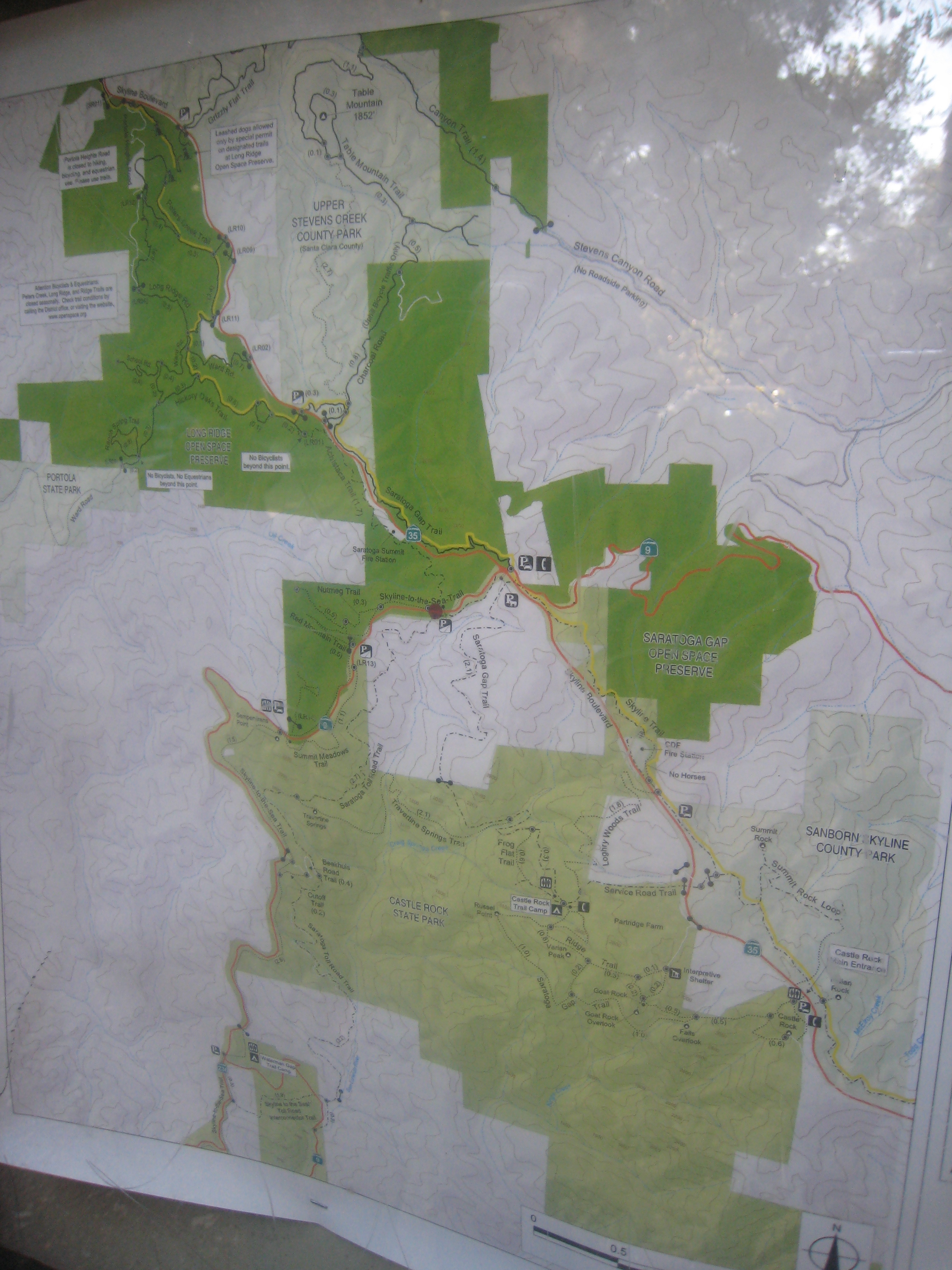
- Castle Rock – near Saratoga, about an hour south of SF (topo map, pics)
- Purisma Creek – 1-1.5 hrs south of SF, nature hike under trees on a hot day (pics, gps)
- Mt. Diablo – Highest Peak in the Bay Area (pics, gps)
- Tilden Park, Berkeley – casual hiking, 1-3 hours (map, pics)
- Mt. Carmel – about 3 hr south of SF, hearty 10 mile roundtrip, 4-7 hours (blog, pics)
- Angel Island – Island in SF Bay, 20min ferry from SF/Tiburon, easy hiking and camping (map, pics)
- More Ideas:
Northern California Hiking/Backpacking Trips
- Sykes Hot Springs (blog, my pics, gps map)
- Where: about 3 hr south of SF – Big Sur, 28 miles south of Carmel CA.
- When: year round, crowded on summer weekends
- Trip: 20 Miles total, 2-3 days
- Pinnacles National Monument
- Trinity Alps (5 hrs north of SF)
- Granite Lake (pics)
- or Coffee Creek up to Caribou Lakes.
- Sierras: Yosemite (4 hrs east of SF)
- Where: about 4-6 hours east of SF, South of Lake Tahoe
- When: late Spring, Summer and Fall
- Notes: One of the most popular parks in the country, can be crowded.
- Many options for trips, 2-
- Half Dome (pics)
- Ten Lakes (1999 pics)
- Tuloumne Canyon (33 miles, 2-3 nights, drive, june/july, shuttle required, maps, nps details)
- Sierras: Sequoia & Kings Canyon National Park (nps.gov)
- Where: about 4-6 hours east of SF, South of Lake Tahoe
- When: Summer and Fall
- Notes: Just south of Yosemite, Similar beauty but less crowded. Campfires allowed usually.
- Many options for trips, 2-6 days
- Day Hike to Mist Falls, camp at Cedar Grove (2006 pics, cedar grove topo map)
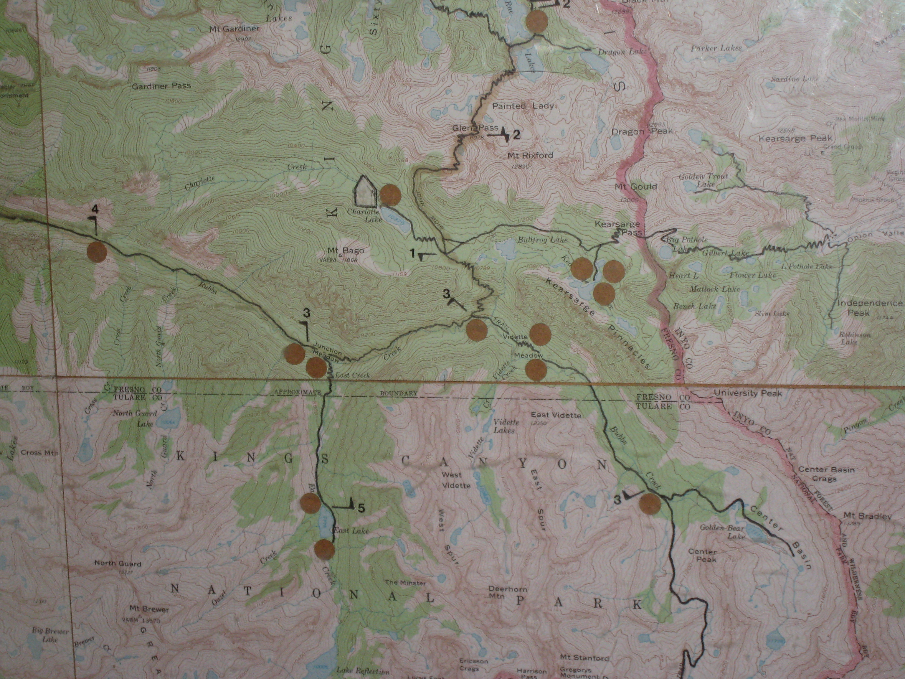
- Bubbs Creek to East Lake (2-3 days, 2008 pics, blog, gps, east lake topo map)
- Jennie Lakes Wilderness and Seville Lake (2004 pics, blog)
- Rae Lakes Loop (43 miles, 3-4 nights, summer/fall, maps)
- Goddard Canyon (2012 pics, blog, 35 miles, 2-4 nights, drive, spring-fall, maps, hot springs, option b, option c)
- Little Five Lakes (50 miles, 4-5 nights, spring-fall, maps)
- Lake Sabrina (dennis suggestion)
- Sierras: Desolation Wilderness
- Where: South Lake Tahoe, 4 hrs from SF, Horsetail Falls good.
- When: Summer, Fall
- Notes: No campfires. Beautiful, Popular, need permits for camping. More.
- Lost Coast
- Where: 230 miles and 4-5 hours north of SF, 80 miles of Cali coast
- link1, gov’t conservation area,
- Snow Mountain Wilderness
- Where: <4 hours north of SF
- When: Summer, Fall
- More:
- Chad’s old list, notes (need to merge)
- Soakers Bible – Hot Springs
- GORP: SF Weekend getaways, California
- Sierra Club: SF Backpacking,
- Winter/Snow trips
- Lake Sabrina near Kings Canyon
- Cosumnes River Gorge rock climbing, swimming hole. Beau’s pics,
- Various activities across USA
- National Trails at Trail Link