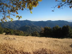
Patagona and Buenos Aires

Just got back from the biggest trip I’ve done since my Round The World in 2007. Shayna and I spent over 2 weeks in South America, mostly to hike the mountains in southern Patagonia, but also to see glaciers and check out Buenos Aires. As you may or may not know, Patagonia refers the southern part of South America – both Chile and Argentina, covering mountains, lakes, and desert regions. Patagonia means “Big feet” – Spanish settlers apparently thought the natives had big feet. Some may call our trip a vacation, but if your definition of a vacation includes relation, pampering, and time to do whatever you want – this was not a vacation. It definitely was an adventure – and we enjoyed it tremendously.
Actual Itinerary (planned itinerary had more days in El Calafate area)
2/14 Fri ORD-GRU, Chicago – Brasil
2/15 Sat – stuck in Sao Paulo Airport, Brasil
2/16 Sun – GRU-EZE, Sao Paulo to Buenos Aires
2/16 Sun – AEP-FTE, Buenos Aires to El Calafate
2/17 Mon – Eco Camp 7-Day W-Trek Begins
2/24 Sun – Eco Camp 7-Day W-Trek Ends
2/25 Mon – El Calafate, Moreno Glacier
2/26 Tue – FTE-AEP – El Calafate to Buenos Aires
3/2 Sun – EZE-GRU-ORD Bye Bye Buones Aires
3/3 Monday, 6am, arrive back at Chicago O’Hare
Our trip began on Valentine’s Day, Friday Feb 14, at 9pm by flying from Chicago to Buenos Aires through Sao Paulo, Brasil. We were supposed to only be in Brasil for a few hours (from 11:40am to 3:40pm), then spend saturday night in BA, then fly from BA to El Calafate on Sunday, then leave El Calafate Monday to begin our 7 day hiking trek in Patagonia. However, we ran into problems in Brasil. TAM, the airline in Brasil, said there was no room on the flight we booked 6 months earlier to BA. Of course this made us happy. But they found a spot on another flight later that night. Then when we were actually boarding the flight, they asked where our print out was of the Argentina reciprocity fee payment … we didn’t have it. Snafu part two. Glad they didn’t bother to ask us in the previous 7 hours we were at the airport. But its not hard to get – just go online, pay, and print. Of course there is like one printer shared amongst all the gates and wifi is soo slow its unusable. TAM did work with us and said they would print it once we paid. We went back to the United VIP lounge to use the wifi there (thank god for the VIP lounge), but we still missed the flight. TAM claimed that United in Chicago should not have let us board without it. Luckily, the United agent at Sao Paulo was extremely understanding and worked with us on getting to BA, as well as tracking our bags down. Between 1 and 2am, over 12 hours after arriving their, we had located the location of our bags (in Buenoes Aires EZE airport), confirmed a new flight to BA, and found a new flight from BA to El Calafate (since we were going to miss our previously planned flight to El Calafate). Also, you can’t purchase one-way tickets to/from El Calafate, so we had to leave El Calafate 2 days earlier than planned – meaning we had to remove El Chalten and Fitz Roy from our trip. The good news is that buying a brand new round trip flight last-minute costs almost the same as buying one a half-year ahead of time. Gotta love “emerging markets”.
Once we arrived in El Calafate, I felt like the Patagonia trip began. We had booked a 7-day W-trek in Torres Del Paine with EcoCamp. I know I wanted to do the W-trek, which is like the most famous trek in Patagonia. Normally we love planning and doing everything ourselves, but we liked how Eco Camp was environmentally friendly, had good food, and would take care of all the details for us – neither Shayna nor I speak Spanish. The first and last day were just getting to/from the camp. So day 1, Monday, we left El Calafate, Argentina, at 7:30am, crossed the border into Chile around noon, and met the EcoCamp guide at the bus station in Puerto Natales, Chile. We signed things, had lunch, and headed north to Torres Del Paine. On the way we stopped at a park and learned about Milodon, an extinct native animal to southern Patagonia. We got to the camp, had happy hour, ate dinner, and slept in our luxiourious bed in a canvas dome. No, really, the bed actually was amazing, had plenty of comforters to keep us warm – no heat and got down to near freezing temps (still warm coming from Chicago where it had not been close to freezing in weeks).
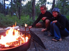
Tuesday, Day 2 of the 7-day trek was our first real day of hiking, roughly 11km (7miles) heading mostly west from Eco Camp (base camp elevation was around 150meters, or 450 feet above sea level). There were 12 of us that paid for this 7-day W-trek, 14 if you include the 2 guides. Each guide had 6 people – but after the first day or two we were just one big group. It was an easy day of hiking in terms of distance and terrain, but was the only day with bad weather – just cloudy, windy and light rain. We spent the night at our first “Refugio”, Refugio Cuernos (78m). Similar to US, backpackers are only allowed to sleep at designated areas in the park, the refugios. You can sleep in a tent or in dorm-style bunk beds. Thats where we stayed. It was packed, and got the late dinner shift. But thats ok, cuz they sold cold-ish beer, and the sun didn’t set till 9pm (summer down by the south pole). We played cards and walked around outside with some of our new Canadian friends. Food was not bad, but definitely not as good as the food at Eco-Camp.
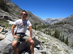
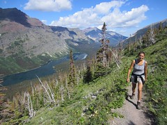
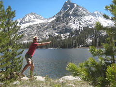
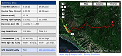
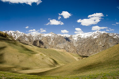
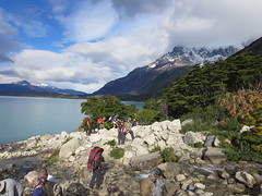
Day 3 was one of my favorites of the trip – 23km (14 miles) in and out of the French Valley. We had a late start (3rd shift for breakfast), but had good weather. It took about 2 hours to hike 5km to Campamento Italiano. From there took another 2 hours to go 5km mostly north straight up the valley to our destination, the Mirador Britanico, aka Britanico Lookout. We had lunch on the way, and the whole way up was amazing views. West of us was the Glaciar del Frances (thats the French Glacier to you and me), and we heard several mini avalanches happening, but i only saw one from start to finish (it was far enough away that by the time you heard it and looked up, it was mostly done). After arriving at Campamento Italiano (170m) for the second time, we headed 7.5km southwest to Refugio Paine Grande (50m). This one was way better than the previous – more like a hotel. We still had dorm-style bunk beds and communal bathrooms, but we had huge cafeteria with good food, good company, great views, and refreshing beer and wine.
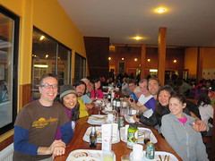
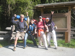
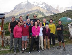
By the end of Day 3 we had made friends with everyone in our group. First there was the 2 guides, Nico (our guide), and Roberto. In our 6-person group there was Shayna and I representing Chicago, Rob and Laurie from Toronto, and Kyong and Marlene from Seattle. In Roberto’s group there was Petros and Lukas from NYC, Carlos and Laura from Mexico City, and Sharon and David from near Boston. Shayna and I were the youngest “couple” there, and Shayna was the youngest one except for the guides. Everybody spoke great English except the couple from Mexico City, who spoke good enough English. Everyone brought their A-Game to this trip. If they were tired you wouldn’t know it from their spirit, and talking on the trails and sharing dinner with everyone was one of the highlights of the trip.
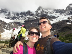
Thursday, Day 4, involved a half day of hiking to the “Grey Glacier” followed by a boat ride and drive back to Eco Camp. It was 10.5km from Refugio Paine Grande to Refugio Grey, where awaited our boat journey. We hiked mostly north along Grey Lake, seeing little blue icebergs floating before we laid eyes on the big real glacier. Even though the lake and glacier were named “Grey”, the glacial ice was blue like most glacial ice. It’s blue because the immense pressure made the ice so dense that only the blue part of the light spectrum can pass all the way through. Although if you take a piece of blue ice and put it in your hands, it does not look blue any more, looks like regular ice. We had lunch at the refugio while waiting for our boat. Inside they had nice couches, hot cocoa, and beer and wine, of course. There was no dock for the boat, had to board via raft. The boat was big, and got close to the “Grey” glacier before zooming back south to let everyone off. The glacier was amazing, but I like Moreno Glacier more (details in El Calafate below). We got off the boat, walked to parking lot, took the standard 15-person Eco-Camp minivan back to basecamp where cocktail hour and dinner awaited.
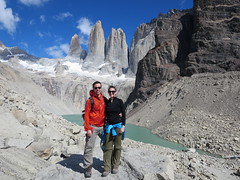
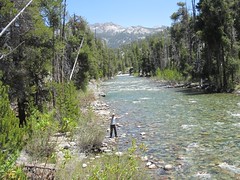
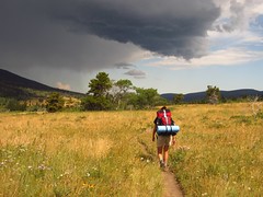
Friday, Day 5, was our last real day of hiking, but one of the best of the trips. We did 18km (11miles) total, to get to Base Las Torres (886m) to see Mirador Las Torres, or as I call it, the lake with a view of the three spires. We hiked 5km north up a valley to Refugio Chileno, which was similar to Refugio Cuernos in size. We didn’t stop long. The next stretch involved hiking right along the river as well as through forests and then at the end a bit of hopping boulder to boulder. But the end was definitely worth it – beautiful. We all took lots of pics, had lunch, and I got a quick nap in. Even though I was still low on sleep, I felt better than I had at any point on the trip. All that exercise and fresh air makes me come alive. On the way down Shayna and I stopped at Hotel Las Torres for wifi and a fresh beer. Beer always tastes best after hiking all day. And shayna needed to check her work emails. The hotel was much nicer than our eco camp, the dining room had giant windows facing north so guests can be in awe of the mountains. And they also had a releif map by the front desk that made it easy to visualize all the mountains and trails we covered the last few days. Glad we stopped in. Then we headed back to camp for shower before cocktails and dinner. Knowing we could finally sleep in the next day, i had a few after dinner drinks and hung out more with people in our group.
Days 6 and 7, the end of the trip, were less exciting, but still interesting. Saturday, Day 6, all 14 of us drove around and looked at the geology and animals. Chile protects the Guanaco, an animal native to patagonia similar to a deer. Well, Chile law forbids humans from killing the Guanaco, but not mountain lions, or Pumas as they prefer to call them. We saw several carcasses – apparently the mountain lion will kill, eat some, then take a few of the good bits back to the kids. They may come back in a day or so to get more. Vultures or other smaller animals might have a snack, too. We also got a little biking in – that was fun – but the bikes were a bit rusty and it was super windy – made it quite a challenge. The day ended early with the standard shower, cocktails, dinner. After dinner everyone had some drinks, told stories, and played Jenga. It was our last night and it was bittersweet. Ok, not really, but i always wanted to say an ending was bittersweet. We had gathered everyone’s emails and promised to share pictures. Day 7 was another early departure – had to leave at 6:30am to catch the bus back to El Calafate. There was a little concern that Marlene might not make it back into Argentina since she didn’t have the correct print out of her Reciprocity fee – but it all worked out.
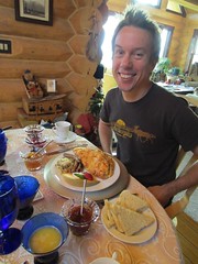
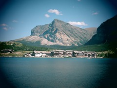
We arrived in El Calafate around 1pm on Sunday. Our hostel room was not great, but it was sunny and grassy out front and I laid down for an hour. That was very nice. Shayna did some work emails (she would spend at least an hour on her laptop each day for the rest of the trip. We also booked our glacier adventure for the next day – we decided to do the mini-hike on the glacier, which includes boat ride and bus. Then we wandered around town looking for dinner, ended up at an Italian-pizza joint (80% of all restaurants in argentina serve pizza or italian). Patagonia Lamb is supposed to be the best meat in the region, and as an avid lover of lamb, I was anxious to try it (never had lamb option in Chile). I wanted the Lamb stew special, but they were out, so I had lamb on my pizza instead. And it was sooo good. I also had a great local weisse beer. El Calafate is approved.
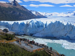
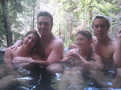
Monday was another one of my favorite days of the trip – seeing Porito Moreno Glacier. This was not my first time on a glacier – i walked around Franz Josef Glacier in New Zealand in 2007. But this one was visually much more impressive. Right up there with mountains as one of the most beautiful awe inspiring things on this planet. We had to pick up lots of people in Calafate, then 60ish of us made a bee-line to the boat, leaving the dock around 11am. We split into 3 groups, one english, two spanish, put on our ice cramp-ons, and climbed around the glacier for about 2 hours. At the end we had some scotch on the rocks, where the rocks where made fresh from glacier ice. Then off the glacier, off with the crampons, ate some lunch, and waited for the boat. On the other side we drove around to the parks main viewing center, and we had an hour to wonder around and see the glacier head-on. It was just so amazing. We were hoping that we’d get to see a big chunk of ice fall in the water, but no dice. Then we took the bus back to Calafate, where we had dinner at El Cucharon. I finally got my Lamb stew and it was deeelicous. Altho I might have enjoyed the lamb on the pizza a bit more. After dinner we did a little shopping and I bought Shayna a ring made from a local artist. Awwww.
Tuesday we had a flight to Buenos Aires later in the afternoon, so we killed time by going to Glaciarium. It’s a glaciar museum with a Ice Bar. We did both. The museum part was very well done, we covered it in one hour. perfect. Then we had a drink in -13 Glacio Bar. Back in Calafate we did some more shopping and headed to Airport. Our flight was uneventful and we arrived at our friend TJ’s apartment in the Palermo district of Buenos Aires. I tried to go out exploring but couldn’t figure out how to leave. Luckily we already ate and didn’t need anything. The next day i figure out that you have to touch the key fob to the special part of this metal box by the gate. Ok, i didn’t figure it out, somebody showed me.
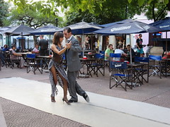
Wednesday through Saturday was mostly sightseeing in Buenos Aires. Highlights include the paid 1 hour tour of Teatro Colon, the Buenos Aires Opera House. We didn’t make it to Mendoza, Argentina’s wine country, but enjoyed wine tasting with Anuva wines, followed by an amazing Italian dinner. We also got a free english guided tour of Recoleta Cemetery where Evita is buried, followed that with Lunch at La Biela, a famous outdoor cafe that comes with a clown playing an accordion. We saw a professional Tango Show as well as Tango in the streets of San Telmo.
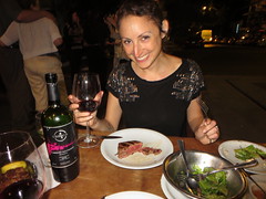
We walked alot around down Buenos Aires – in awe of the grandeur and humbled by protestors, squeezed in some shopping, bought shoes for shayna, and pants and shirts for me. And many delicious meals, including an amazing middle eastern joint called Sarkis, our favorite cafe, Sans, in Palermo Viejo, which was about 20 minute walk from TJ’s apt where we stayed. Last but not least, we had to eat what Argentina’s famous for – great steaks. We hit 2 parrillas – La Brigada and Don Julio. We both like Don Julio better, probably because we had meat more like a filet mingon.
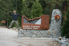
In conclusion I’d recommend Patagonia to everyone who likes the outdoors, loves to travel, or wants something awe inspiring. It’s up there with my favorite mountains in the world – others being Sierra Nevadas (Yosemite or Kings Canyon), Rocky Mountains (Glacier National Park), and Himalayas (Lamayuru Trek), and maybe the Swiss Alps. However, if you are watching the wallet, skip the EcoCamp and plan the W-trek hike yourself. Make sure you check out all my “Best of” pics, either on flickr or in my facebook album (assuming we’re connected). If you’re daring, you can check out all my pics on flickr (635 in patagonia, 143 in Buenos Aires). Note that we whittled those 800ish pics down from 2,000. The next big trip is Alaska – shooting for summer 2015.